




Territory Energy Link is a Northern Territory Government initiative to establish a strategic multi-user infrastructure corridor connecting the Beetaloo to Darwin.
The proposed 670-kilometre corridor will provide a planned pathway for future gas, water, fibre and other infrastructure, helping connect one of the Territory’s most significant emerging resource regions with Darwin, industry and markets.
With the Beetaloo Basin moving into gas production, planning for the infrastructure needed to support its longer-term development is becoming increasingly important.
By planning a single shared corridor now, Territory Energy Link aims to support future private investment, reduce duplication and provide a coordinated approach to infrastructure development across the Territory.
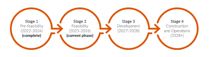
Territory Energy Link is currently in the feasibility phase, with on-ground investigations, engineering, environmental and cultural studies, corridor refinement and stakeholder engagement underway.
Territory Energy Link on the ground
Government's role
The Northern Territory Government is responsible for planning, securing and establishing the Territory Energy Link corridor. Government is not proposing to construct the individual pipelines or utilities that may ultimately use the corridor.
Future infrastructure will be designed, funded, approved and constructed by proponents as projects progress and demand emerges. By doing the corridor planning now, government can address land, access, technical, environmental and cultural considerations at a strategic level and create greater certainty for future infrastructure investment.
What infrastructure could be accommodated?
Territory Energy Link is being planned as a flexible, multi-user corridor that could accommodate infrastructure including:
- gas pipelines
- water pipelines
- optical fibre and communications infrastructure
- other future utilities and services.
Co-locating infrastructure within one managed corridor can reduce duplication while providing flexibility to respond to the Territory’s future infrastructure needs.
For more information, download the project fact sheet PDF (1.1 MB).
Territory Energy Link preliminary alignment map
Disclaimer: this map is for illustrative purposes only. The corridor alignment and planning area is subject to further detailed technical investigations and consultation.
Territory Energy Link is progressing through its feasibility phase, with planning increasingly moving from desktop studies to detailed technical and on-ground investigations.
- Geotechnical investigations
Targeted geotechnical investigations are underway along the proposed corridor to build a clearer understanding of soil, rock, river crossings and other ground conditions.
The results will help identify geotechnical risks and constructability constraints, inform potential engineering solutions and support refinement of the preferred corridor alignment.
- Engineering and concept design
Engineering work is progressing to develop the feasibility-level concept design and undertake constructability assessment of the corridor.
This work will bring together findings from geotechnical, environmental, cultural and other investigations to better understand how future infrastructure could be accommodated within Territory Energy Link.
- Corridor refinement
The preliminary alignment continues to be refined as new technical information and stakeholder feedback becomes available.
Potential route changes are considered across multiple disciplines, including engineering and constructability, environmental values, sacred sites and cultural heritage, land use, pastoral operations, access and existing infrastructure.
- Environmental and cultural investigations
Environmental and cultural heritage work continues along the proposed corridor, including engagement with Traditional Owners and the Aboriginal Areas Protection Authority.
These investigations are helping identify areas that should be avoided or carefully managed as the preferred alignment is developed.
- Landholder and stakeholder engagement
The Territory Energy Link team continues to work directly with pastoralists, landholders, Traditional Owners, councils, industry and government agencies.
Local knowledge and stakeholder feedback are an important part of the feasibility process and are helping inform both the corridor alignment and how future access and corridor arrangements could operate. These investigations and activities will help inform the preferred corridor alignment.
The Territory Energy Link project stages:
Direct engagement is central to the Territory Energy Link feasibility process.
The project team is working with landowners, land occupiers, Traditional Owners, councils, regional communities and industry to better understand local conditions, potential impacts and opportunities.
Before field investigations occur, the project team works with affected landholders and stakeholders to provide information about the proposed activities, access requirements and timing.
As planning progresses, the department will continue to provide updates and opportunities for stakeholders to speak directly with the project team.
If you have questions about Territory Energy Link, upcoming investigations or the proposed corridor, we are happy to meet and discuss the project.
For more information about Territory Energy Link, email territoryenergylink.dli@nt.gov.au or call 1800 921 301.
To register to receive project updates, email territoryenergylink.dli@nt.gov.au.
Any personal information collected through the Territory Energy Link project will be managed in accordance with the Northern Territory Information Act 2002 and the Department of Logistics and Infrastructure Privacy Policy. For more information, go to the Department of Logistics and Infrastructure website.